მესამე საერთაშორისო კონფერენცია –
“მონიტორინგი ჰიდროელექტროსადგურების სიცოცხლისუნარიანობის გახანგრძლივებისათვის”
ცოდნის გადაცემის მიღმა
თბილისის სახელმწიფო უნივერსიტეტი
17 აპრილი, 2024 წ.
ი. ჭავჭავაძის გამზირი 1, მეორე სართული, სააქტო დარბაზის ლობი
კონფერენციის მიზნები
—————————————————————————————————
2022 წლის 21- 22 ნოემბერს ივანე ჯავახიშვილის სახელობის თბილისის სახელმწიფო უნივერსიტეტში ჩატარდა ახალგაზრდა მეცნიერთა საერთაშორისო კონფერენცია “დედამიწის შემსწავლელი მეცნიერების თანამედროვე პრობლემები”. კონფერენციის ორგანიზატორები იყვნენ მიხეილ ნოდიას სახელობის გეოფიზიკის ინსტიტუტი და ჰიდრომეტეოროლოგიის ინსტიტუტი.
Slide content
Slide content
Slide content
ქართველი სეისმოლოგი, აკადემიკოსი თამაზ ჭელიძე
ბრიტანეთის სამეფო ასტრონომიული საზოგადოების საპატიო წევრი ხდება
საინჟინრო სეისმოლოგია
ინჟინრული ამოცანების გადაწყვეტა
 შენობა-ნაგებობების მოდელური ანალიზი (საკუთარი პერიოდებისა და ფორმების მიხედვით);
- ვიბრაციული დონეების დადგენა (სანიტარული. ტექნოლოგიური, კონსტრუქციული და სხვა ნორმების შესაბამისად);
- შენობა-ნაგებობების დაზიანების ხარისხის შეფასება (ბუნებრივი და ტექნოგენური კატასტროფების შემთხვევაში);
- ლიცენზირებული პროგრამები EZFRISK, Openquake, ELER V3 რომელიც საშუალებას გვაძლევს გადავწყვიტოთ შემდეგი ამოცანები:
- სეისმური საშიშროების ალბათური შეფასება პიკურ და სპექტრალურ აჩქარებებში;
სეისმური საშიშროების დეზაგრეგაცია; - სეისმური საშიშროების დეტერმინისტული შეფასება, სცენარული მიწისძვრების გათვლა ;
- საინჟინრო სეისმოლოგიის ამოცანები:
ჰიდროგეოფიზიკისა და გეოთერმიის ამოცანები
ჰიდროგეოფიზიკის თანამედროვე მეთოდებით მიწისქვეშა წყლების რესურსების შესწავლა, მათი ასაკის და დინამიკური რეჟიმის დადგენა გარემოს დაჭუჭყიანების შესამცირებლად, საინჟინრო ამოცანების გადასაწყვეტად და განახლებადი ენერგიის წყაროების შესაქმნელად
 მიწისქვეშა წყლების ეკოლოგიური - სტაბილური და რადიაქტიული იზოტოპების „ტრასერებად“ გამოყენებით წყლის ნაკადის მოძრაობის გზების დადგენა და დაბინძურების ხარისხის შეფასება;
- წყალშემცველი ჰორიზონტების ჩაწოლის სიღრმისა და სივრცეში განლაგების დადგენა კვლევის გეოლოგიური და გეოფიზიკური მეთოდების გამოყენებით;
საინჟინრო გეოფიზიკა
საინჟინრო გეოფიზიკის მეთოდებით (სეისმური, ელექტრული, მაგნიტური, გეორადიოლოკაცია) სამშენებლო მოედნების გეოლოგიური სტრუქტურის დადგენა, მეწყრების, ღვარცოფების და სხვა მავნე ეგზოგენური პროცესების შესწავლა და რისკის შემცირება.
დიდი საინჟინრო ობიექტების დეფორმაციების ავტომატური ტელემეტრული მონიტორინგის და ადრეული შეტყობინების სისტემები (განხორციელებულია ენგურის საერთაშორისო გეოდინამიკური პოლიგონის ბაზაზე)
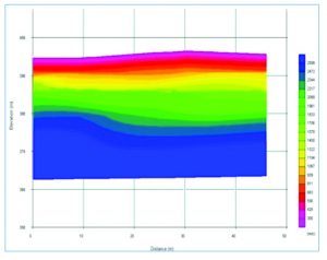
ქ. თბილისში, პუშკინის ქუჩის რეკონსტრუქციისათვის გეოფიზიკური მეთოდებით ჩატარებული გამოკვლევები - ნაჩვენებია სეისმურ ჭრილებში გამოყოფილი გეოფიზიკური თვისებებით განსხვავებული სამი ძირითადი შრე. შედეგები სრულად დადასტურდა ჭაბურღილების მონაცემებით.
გეორადიოლოკაცია (გეორადარი)კონსტრუქციების კონტროლსა და საინჟინრო არქეოლოგიაში
გეორადარი გამოიყენება ბეტონის კონსტრუქციებში არმატურების, მილების, კაბელების,
სიცარიელეების, დეფექტური უბნების ზუსტი ადგილმდებარეობის დასადგენად ბურღვისა და გამონგრევის გარეშე რეალურ დროში, რაც ძალზე სასარგებლოა რემონტების და რეკონსტრუქციის დროს. გეორადარი ბოლო წლებში სულ უფრო ხშირად გამოიყენება დიდი საინჟინრო ობიექტების სამშენებლო მოედნებზე დაფარული არქეოლოგიური ძეგლების სწრაფი დაძიებისათვის. არქეოგეოფიზიკა შესაძლებლობას იძლევა სწრაფად, იაფად და ზუსტად დადგინდეს დაფარული ობიეექტის (ძეგლის) ადგილმდებარეობა, მისი ჩაწოლის სიღრმე, ზომები და სხვა დეტალები.
საშიში ბუნებრივი მოვლენები და
ადრეული შეტყობინების სისტემები
საქართველოს ტერიტორია ერთ-ერთი ყველაზე მოწყვლადი მაღალმთიანი რეგიონია მსოფლიოში.  ინსტიტუტი ამუშავებს ღვარცოფების/მეწყრების ადრეული შეტყობინების ტელემეტრული სისტემებს (აშტს), რაც გულისხმობს ეკონომიური და სანდო გეოფიზიკური მონიტორინგის ინოვაციური კომპლექსის შექმნას ავტონომური კვებით, რომელიც გვამცნობს კატასტროფული მოვლენის მოახლოებას (დაწყებას) რადიოსიგნალების ან ინტერნეტის საშუალებით. ფაქტობრივად, დანადგარი წარმოადგენს დიაგნოსტურ სისტემას, რომელიც უწყვეტად აგროვებს ლოკალურ ინფორმაციას, ადარებს მას წინასწარ შემუშავებულ კრიტერიუმებს (სინოტივის, დახრების და დიფერენციალური აჩქარების კრიტიკულ მნიშვნელობებს) და იღებს გადაწყვეტილებას სხვადასხვა დონის გამაფრთხილებელი სიგნალის დისტანციური გადაცემის შესახებ.
გეოეკოლოგიური უსაფრთხოება
თუ გსურთ ახალი მშენებლობის წამოწყებისას ან რაიმე ობიექტის შეძენისას იცოდეთ -რამდენად მდგრადია ეს სამშენებლო მოედანი ან შენობა კატასტროფებისადმი (მიწისძვრა, მეწყრები, წყალმოვარდნები), პროფესიონალები გაგიწევენ კონსულტაციას - დაადგენენ თქვენი ოფისის თუ საცხოვრებელი სახლის მოსალოდნელ საშიშროებათა დონეს.
ყოველი სახის კონსულტაციაზე გაიცემა შესაბამისი სერტიფიკატი, სადაც დაზუსტებული იქნება რისკის დონე და კონკრეტული რეკომენდაციები, რომლებიც ხელს შეუწყობენ ობიექტის მდგრადობის გაუმჯობესებას ამა თუ იმ საშიშროების მიმართ.
ჩვენ დაგიდგენთ:
სეისმურ საშიშროებას (აქტიური რღვევის სიახლოვე, მოსალოდნელი ბალი, პიკური და სპექტრალური აჩქარება);
ბუნებრივი მულტი-საშიშროებების კარტირებას (12 საშიშროება);
გრუნტის, ფუნდამენტისა და შენობის მდგომარეობას (მდგრადობას);
რადიოაქტივობის დონეს, რადონის კონცენტრაციას;
ელექტრომაგნიტური გამოსხივების დონეს;
ხმაურის დონეს;
წყლის შემადგენლობას/ხარისხს/ასაკს;
ჰაერის ხარისხს/დაჭუჭყიანებას;
მეწყრის, ღვარცოფის და გრუნტის დაწევის საშიშროებას;
გეომაგნიტურ პროგნოზს;
ავტომატური ტელემეტრული მონიტორინგის ოპტიმალურ სისტემას.
DAMAST – მონიტორინგის ტექნოლოგია ჰიდროელექტროსადგურების
უსაფრთხო და ეფექტური მუშაობისთვის
სრულად >>
ძვირფასო კოლეგებო,
2019 წლის 12-14 დეკემბერს თბილისში ივანე ჯავახიშვილის სახელობის თბილისის სახელმწიფო უნივერსიტეტში ჩატარდება საერთაშორისო სამეცნიერო კონფერენცია თემაზე „ბუნებრივი კატასტროფები საქართველოში: მონიტორინგი, პრევენცია, შედეგების შერბილება“. კონფერენცია ეძღვნება საქართველოში რეგულარული მაგნიტურ-მეტეოროლოგიური და სეისმური დაკვირვებების ორგანიზების 175 და 120 წლისთავს.
გიწვევთ კონფერენციის მუშაობაში მონაწილეობის მისაღებად!
ვებგვერდი:http://4science.ge/conferences/index.php/CONF/CONF
კონფერენციის ელ-ფოსტა: ndgconference@4science.ge
საკონტაქტო პირები:
ნინობერიანიძე – ელ. ფოსტა:nikoli700@yahoo.com, მობ.: +995 598303600
მანანანიკოლაიშვილი – ელ. ფოსტა:manananikola@gmail.com,მობ.: +995 557 23 62 90
მიხეილფიფია –ელ. ფოსტა:m.pipia@gtu.ge,მობ.: +995 593 55 65 11
დანართი: 1. 1-ლი საინფორმაციო წერილი,2. სარეგისტრაციო ბარათი, 3. მოთხოვნები სტატიის გაფორმებისათვის (3 ფაილი).
პატივისცემით, საორგანიზაციო კომიტეტი
შოთა რუსთაველის ეროვნული სამეცნიერო ფონდის მიერ დაფინანსებული
გამოყენებითი გრანტი “მეწყრების მონიტორინგის და ადრეული
შეტყობინების ეკონომიური ტელემეტრული სისტემის შექმნა”
მოკლე აღწერა იხ. ბმული
საბოლოო ანგარიში იხ. ბმული
გამოყენებითი გეოფიზიკა მშენებლობაში
- შენობების, საავტომობილო გზების, რკინიგზების, ხიდების, მილსადენების, გვირაბების, კაშხლების, მცირე ჰესების და სხვა საინჟინრო ობიექტების სამშენებლო მოედნების გეოლოგიურ-გეოფიზიკური ჭრილების აგება;
- მეწყრების გეოლოგიური ჭრილების და კონტურების დადგენა, კარსტების და გვირაბების ადგილმდებარეობის დადგენა;
- შენობების დეფორმაციის მონიტორინგი დახრისმზომებით; სამაშველო-საძიებო სამუშაოები;
- ტერიტორიის ქვეზედაპირული გეოლოგიური სტრუქტურის დადგენა;
- მიწისქვეშა წყლების ძიება და გრუნტის წყლის დონის/ასაკის დადგენა, რეზერვუარის სამგანზომილებიანი კომპიუტერული მოდელირება, წყლის გაჟონვის ლოკალიზება;
- გეოთერმული სისტემების დაგეგმვა და ოპტიმალური მართვა;
- სამშენებლო მოედნების გრუნტის მექანიკური თვისებების დადგენა დრეკადი განივი ტალღების მეთოდით (Vs30) 30 მეტრის სიღრმემდე;
- დაფარული არქეოლოგიური ობიექტების დაძიება;
- გეოეკოლოგიური უსაფრთხოება (იხილეთ შემდეგ გვერდზე);
- ქანების და სამშენებლო მასალების სითბური და ულტრაბგერითი მეთოდით დრეკადი თვისებების გაზომვა.
- ბეტონის ხარისხის შემოწმება ულტრაბგერითი მეთოდით;
- გეოფიზიკური კვლევები აბსოლუტურად არ აზიანებს დაფარულ ძეგლებს.
კვლევა სრულდება უმოკლეს ვადებში, რაც განპირობებულია საველე სამუშაოებში ძიების უახლესი აპარატურის და მეთოდიკის, მონაცემთა დამუშავებისა და შედეგების ვიზუალიზაციისთვის თანამედროვე პროგრამული სისტემების გამოყენებით.
დასმული ამოცანის მიხედვით შეირჩევა სეისმური, ელექტრული, მაგნიტური ან კომპლექსური ძიების მეთოდიკა. მოცულობის და დანახარჯების ოპტიმალური ვარიანტი. შეირჩევა შემკვეთისთვის ხელსაყრელი კონტრაქტის პირობები. გეოფიზიკური კვლევის მეთოდების დეტალური აღწერა იხილეთ ქვემოთ.
კვლევის შედეგების ანგარიში კომპლექტდება: გრაფიკული მასალით (დაკვირვების სქემა, ჭრილები და რუკები GIS სისტემაში); ცხრილებით (ქანების ფიზიკურ-მექანიკური მახასიათებლები, GSI); ციფრული ვარიანტით, შედეგების ორ და სამ განზომილებიანი ვიზუალიზაციით; სხვა ენაზე თარგმანით.
